קובץ:Bastille, 1734.jpg
אין גרסה ברזולוציה גבוהה יותר.
Bastille,_1734.jpg (485 × 287 פיקסלים, גודל הקובץ: 57 ק"ב, סוג MIME: image/jpeg)
| זהו קובץ שמקורו במיזם ויקישיתוף. תיאורו בדף תיאור הקובץ המקורי (בעברית) מוצג למטה. |
| תיאור |
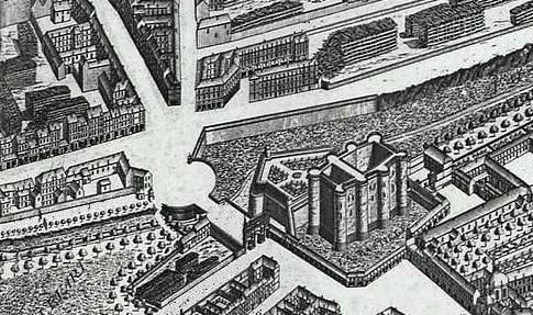
English: Map of Paris called "Plan de Turgot" Français : Plan de Paris dit Plan de Turgot |
| תאריך יצירה | (UTC) |
| מקור | |
| יוצר |
|
| זוהי תמונה מרוטשת, זאת אומרת שהתמונה שונתה בצורה דיגיטלית מהמקור. Modifications: Trimmed back to show just the Bastille. את התמונה המקורית ניתן לראות ב: Plan de Turgot.jpg. השינוי בוצע על ידי Hchc2009.
|
|
יצירה זו נמצאת בנחלת הכלל במדינת המקור ובמדינות אחרות בהם תקופת זכויות היוצרים היא משך חיי היוצר ו-70 שנה (או פחות) מפטירתו.
| |
| הקובץ הזה זוהה כקובץ חופשי מכל מגבלה ידועה תחת חוק זכויות היוצרים, כולל כל הזכויות הקשורות והסמוכות. | |
יומן העלאה מקורי
This image is a derivative work of the following images:
- File:Plan_de_Turgot.jpg licensed with Cc-pd-mark-footer, PD-old
- 2009-07-20T20:42:34Z Tangopaso 6552x5101 (14985900 Bytes) {{Information |Description={{en|1=Map of Paris called "Plan de Turgot"}} {{fr|1=Plan de Paris dit Plan de Turgot}} |Source=http://perso.numericable.fr/parisbal/plans/1739_Turgot.jpg |Date=1736 |Author=[[:fr:Louis Bretez]] |Pe
Uploaded with derivativeFX
היסטוריית הקובץ
ניתן ללחוץ על תאריך/שעה כדי לראות את הקובץ כפי שנראה באותו זמן.
| תאריך/שעה | תמונה ממוזערת | ממדים | משתמש | הערה | |
|---|---|---|---|---|---|
| נוכחית | 20:00, 6 באוגוסט 2011 | | 287 × 485 (57 ק"ב) | Hchc2009 | {{Information |Description={{en|1=Map of Paris called "Plan de Turgot"}} {{fr|1=Plan de Paris dit Plan de Turgot}} |Source=*File:Plan_de_Turgot.jpg |Date=2011-08-06 16:55 (UTC) |Author=*File:Plan_de_Turgot.jpg: fr:Louis Bretez *derivative |
שימוש בקובץ
הדף הבא משתמש בקובץ הזה:
שימוש גלובלי בקובץ
אתרי הוויקי השונים הבאים משתמשים בקובץ זה: