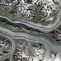
קובץ:Glacier Bay National Park SPOT 1237.jpg

לקובץ המקורי (6,000 × 6,000 פיקסלים, גודל הקובץ: 33.8 מ"ב, סוג MIME‏: image/jpeg)

ויקישיתוף זהו קובץ שמקורו במיזם ויקישיתוף. תיאורו בדף תיאור הקובץ המקורי (בעברית) מוצג למטה.

תקציר

תיאור
English: Logan and Walsh Glaciers, by SPOT-5 Satellite
Deutsch: oben Walsh-Gletscher, unten Logan-Gletscher, im kanadischen Teil der Eliaskette
תאריך יצירה
מקור http://gallery.spotimage.com/product_info.php?products_id=1237 - https://www.intelligence-airbusds.com/en/5751-image-gallery-details?img=775
יוצר Cnes - Spot Image
אישורים והיתרים
(שימוש חוזר בקובץ זה)

Removed Watermark: (c) Cnes - Distribution Spot Image

מיקום המצלמה60° 49′ 31.8″ N, 140° 42′ 19.29″ W Kartographer map based on OpenStreetMap.תמונה זו ותמונות נוספות במיקום: OpenStreetMapinfo

רישיון

אני, בעל זכויות היוצרים על עבודה זו, מפרסם בזאת את העבודה תחת הרישיון הבא:
w:he:Creative Commons
ייחוס שיתוף זהה
הקובץ הזה מתפרסם לפי תנאי רישיון קריאייטיב קומונז ייחוס-שיתוף זהה 3.0 לא מותאם.
יש לך חופש:
  • לשתף – להעתיק, להפיץ ולהעביר את העבודה
  • לערבב בין עבודות – להתאים את העבודה
תחת התנאים הבאים:
  • ייחוס – יש לתת ייחוס הולם, לתת קישור לרישיון, ולציין אם נעשו שינויים. אפשר לעשות את זה בכל צורה סבירה, אבל לא בשום צורה שמשתמע ממנה שמעניק הרישיון תומך בך או בשימוש שלך.
  • שיתוף זהה – יצירת רמיקס, שינוי או בנייה על סמך החומר הזה, תטיל עליך חובה להפיץ את התרומות שלך לפי תנאי רישיון זהה או תואם למקור.


Textual information (e.g. timestamp) once visible in the image itself has been moved into the image metadata and/or image description page. This makes the image easier to reuse and more language-neutral, and makes the text easier to process and search for. Commons discourages placing visible textual information in images. All licenses accepted on Commons permit this type of modification as a derivative work. If attribution information were removed and the image is not public domain, replace this tag with {{Attribution metadata from licensed image}}.

беларуская (тарашкевіца)‎ | català | Deutsch | English | español | فارسی | français | galego | magyar | italiano | македонски | മലയാളം | português | русский | sicilianu | slovenščina | svenska | Indonesia | 中文 | +/−

Annotations
InfoField
This image is annotated: View the annotations at Commons

כיתובים

נא להוסיף משפט שמסביר מה הקובץ מייצג

פריטים שמוצגים בקובץ הזה

מוצג

Ogilvie Glacier אנגלית

60°49'31.804"N, 140°42'19.285"W

היסטוריית הקובץ

ניתן ללחוץ על תאריך/שעה כדי לראות את הקובץ כפי שנראה באותו זמן.

תאריך/שעהתמונה ממוזערתממדיםמשתמשהערה
נוכחית16:35, 9 באוקטובר 2021תמונה ממוזערת לגרסה מ־16:35, 9 באוקטובר 2021‪6,000 × 6,000‬ (33.8 מ"ב)Don-viphigher res version
06:07, 12 ביולי 2008תמונה ממוזערת לגרסה מ־06:07, 12 ביולי 2008‪500 × 500‬ (110 ק"ב)Jarekt{{Information |Description=Cropped watermark |Source= |Date= |Author= |Permission= |other_versions= }}
15:13, 11 באפריל 2008תמונה ממוזערת לגרסה מ־15:13, 11 באפריל 2008‪500 × 500‬ (115 ק"ב)Spot Image{{Information |Description= Glacier Bay National Park by SPOT Satellite |Source=http://gallery.spotimage.com/product_info.php?products_id=1237 |Date=2004 |Author= Cnes - Spot Image |Permission= |other_versions= }} [[Category:SPOT sate

הדף הבא משתמש בקובץ הזה:

שימוש גלובלי בקובץ

אתרי הוויקי השונים הבאים משתמשים בקובץ זה:

מטא־נתונים