לקובץ המקורי (3,072 × 3,072 פיקסלים, גודל הקובץ: 1.9 מ"ב, סוג MIME‏: image/jpeg)

ויקישיתוף זהו קובץ שמקורו במיזם ויקישיתוף. תיאורו בדף תיאור הקובץ המקורי (בעברית) מוצג למטה.

תקציר

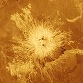
תיאור This false-color image shows the volcano Sapas Mons, which is located in the broad equatorial rise called Atla Regio (8 degrees north latitude and 188 degrees east longitude). The area shown is approximately 650 kilometers (404 miles) on a side. Sapas Mons measures about 400 kilometers (248 miles) across and 1.5 kilometers (0.9 mile) high. Its flanks show numerous overlapping lava flows. The dark flows on the lower right are thought to be smoother than the brighter ones near the central part of the volcano. Many of the flows appear to have been erupted along the flanks of the volcano rather than from the summit. This type of flank eruption is common on large volcanoes on Earth, such as the Hawaiian volcanoes. The summit area has two flat-topped mesas, whose smooth tops give a relatively dark appearance in the radar image. Also seen near the summit are groups of pits, some as large as one kilometer (0.6 mile) across. These are thought to have formed when underground chambers of magma were drained through other subsurface tubes and lead to a collapse at the surface. A 20 kilometer-diameter (12-mile diameter) impact crater northeast of the volcano is partially buried by the lava flows. Little was known about Atla Regio prior to Magellan. The new data, acquired in February 1991, show the region to be composed of at least five large volcanoes such as Sapas Mons, which are commonly linked by complex systems of fractures or rift zones. If comparable to similar features on Earth, Atla Regio probably formed when large volumes of molten rock upwelled from areas within the interior of Venus known as'hot spots.' Magellan is a NASA spacecraft mission to map the surface of Venus with imaging radar. The basic scientific instrument is a synthetic aperture radar, or SAR, which can look through the thick clouds perpetually shielding the surface of Venus. Magellan is in orbit around Venus which completes one turn around its axis in 243 Earth days. That period of time, one Venus day, is the length of a Magellan mapping cycle. The spacecraft completed its first mapping cycle and primary mission on May 15, 1991, and immediately began its second cycle. During the first cycle, Magellan mapped more than 80 percent of the planet's surface and the current and subsequent cycles of equal duration will provide complete mapping of Venus. Magellan was launched May 4, 1989, aboard the space shuttle Atlantis and went into orbit around Venus August 10, 1990.
מקור http://photojournal.jpl.nasa.gov/catalog/PIA00203
יוצר JPL/NASA
This image or video was catalogued by Jet Propulsion Laboratory of the United States National Aeronautics and Space Administration (NASA) under Photo ID: PIA00203.

This tag does not indicate the copyright status of the attached work. A normal copyright tag is still required. See Commons:Licensing.
Other languages:

רישיון

Public domain קובץ זה נמצא ברשות הציבור מכיוון שהוא נוצר על ידי נאס"א. מדיניות זכויות היוצרים של נאס"א קובעת ש"חומרים של NASA אינם מוגנים בזכויות יוצרים אלא אם צוין אחרת". (דף מדיניות זכויות היוצרים ב-NASA או מדיניות שימוש בתמונות ב-JPL).
אזהרות:
  • שימוש בלוגואים, סמלים וטלאים של נאס"א כפוף להגבלה של החוק בארצות הברית 14 CFR 1221.
  • אתר האינטרנט של נאס"א מכיל תמונות רבות שמקורן מתוכנית החלל הסובייטית/סוכנות החלל הרוסית, וחומרים נוספים של סוכנויות חלל אחרות. קבצים אלו אינם בהכרח תחת רשות הציבור.
  • חומרים מטלסקופ החלל האבל עשויים להיות מוגנים בזכויות יוצרים אם לא מצוין במפורש שהגיעו מSTScI. [1]
  • כל החומרים שנוצרו על ידי חללית SOHO מוגנים בזכויות יוצרים ודורשים הרשאה עבור שימוש מסחרי לא חינוכי. [2]
  • תמונות המוצגות באתר Astronomy Picture of the Day (APOD) עשויים להיות מוגנים בזכויות יוצרים. [3]
Annotations
InfoField
This image is annotated: View the annotations at Commons

כיתובים

נא להוסיף משפט שמסביר מה הקובץ מייצג

פריטים שמוצגים בקובץ הזה

מוצג

היסטוריית הקובץ

ניתן ללחוץ על תאריך/שעה כדי לראות את הקובץ כפי שנראה באותו זמן.

תאריך/שעהתמונה ממוזערתממדיםמשתמשהערה
נוכחית00:58, 25 בנובמבר 2007תמונה ממוזערת לגרסה מ־00:58, 25 בנובמבר 2007‪3,072 × 3,072‬ (1.9 מ"ב)Lotse{{Information |Description=This false-color image shows the volcano Sapas Mons, which is located in the broad equatorial rise called Atla Regio (8 degrees north latitude and 188 degrees east longitude). The area shown is approximately 650 kilometers (404

שימוש גלובלי בקובץ

אתרי הוויקי השונים הבאים משתמשים בקובץ זה:

מטא־נתונים