קובץ:Southern Paramushir Island, Kuril Chain, Russia.JPG
לקובץ המקורי (2,807 × 4,256 פיקסלים, גודל הקובץ: 1.84 מ"ב, סוג MIME: image/jpeg)
| זהו קובץ שמקורו במיזם ויקישיתוף. תיאורו בדף תיאור הקובץ המקורי (בעברית) מוצג למטה. |
תקציר
| תיאור |
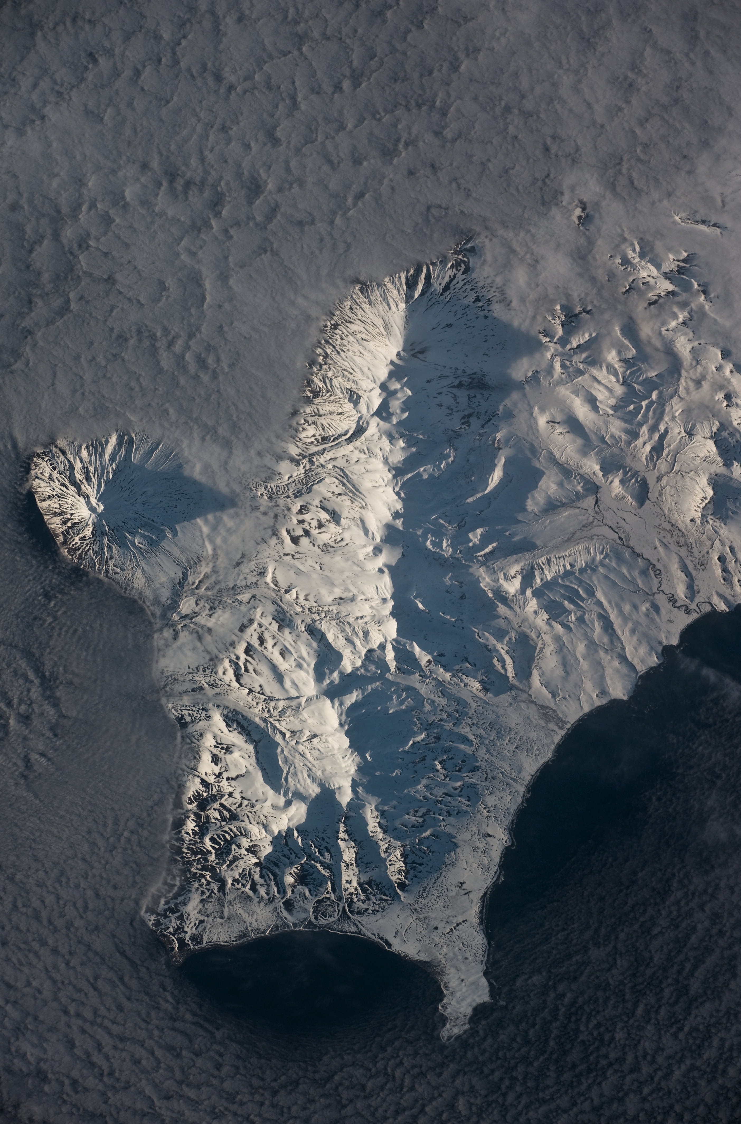
English: This astronaut photograph shows the southern end of Paramushir Island after a snowfall. The western slopes of the mountains are brightly illuminated, while the eastern slopes are in shadow.
Four major volcanic centres create this part of the island. Fuss Peak (image centre left) is an isolated stratovolcano connected to the main island via an isthmus. Fuss Peak last erupted in 1854. The southern tip of the island is occupied by the Karpinsky Group of three volcanic centres. A minor eruption of ash following an earthquake occurred on this part of the island in 1952. The Lomonosov Group to the north-east (image centre) includes four cinder cones and a lava dome that produced several lava flows in the past, but there have been no eruptions from the Lomonosov Group in recorded history. The most recent volcanic activity on Paramushir Island occurred in 2008 at the Chikurachki cone located along the northern coastline of the island at image top centre. The summit of this volcano [1,816 meters above sea level] is the highest on Paramushir Island. Much of the Sea of Okhotsk visible in the image is covered with low clouds that often form around the islands in the Kuril chain. The clouds are generated by moisture-laden air passing over the cool sea/ocean water, and they typically wrap around the volcanic islands. |
| תאריך יצירה | |
| מקור | NASA Earth Observatory |
| יוצר | ISS Expedition 23 crew |
| מיקום המצלמה | | תמונה זו ותמונות נוספות במיקום: OpenStreetMap |
|---|
This image or video was catalogued by Johnson Space Center of the United States National Aeronautics and Space Administration (NASA) under Photo ID: ISS023-E-58455. This tag does not indicate the copyright status of the attached work. A normal copyright tag is still required. See Commons:Licensing. Other languages:
|
Image acquired with a Nikon D3 digital camera using an effective 280 mm lens, and is provided by the ISS Crew Earth Observations experiment and Image Science & Analysis Laboratory, Johnson Space Center.
רישיון
| קובץ זה נמצא ברשות הציבור מכיוון שהוא נוצר על ידי נאס"א. מדיניות זכויות היוצרים של נאס"א קובעת ש"חומרים של NASA אינם מוגנים בזכויות יוצרים אלא אם צוין אחרת". (דף מדיניות זכויות היוצרים ב-NASA או מדיניות שימוש בתמונות ב-JPL). | ||
 |
אזהרות:
|
| Annotations | This image is annotated: View the annotations at Commons |
היסטוריית הקובץ
ניתן ללחוץ על תאריך/שעה כדי לראות את הקובץ כפי שנראה באותו זמן.
| תאריך/שעה | תמונה ממוזערת | ממדים | משתמש | הערה | |
|---|---|---|---|---|---|
| נוכחית | 13:33, 12 ביולי 2010 | | 4,256 × 2,807 (1.84 מ"ב) | Originalwana | {{Information |Description={{en|1=This astronaut photograph shows the southern end of Paramushir Island after a snowfall. The western slopes of the mountains are brightly illuminated, while the eastern slopes are in shadow. Four major volcani |
שימוש בקובץ
הדף הבא משתמש בקובץ הזה:
שימוש גלובלי בקובץ
אתרי הוויקי השונים הבאים משתמשים בקובץ זה:
- שימוש באתר arz.wiki.x.io
- שימוש באתר be.wiki.x.io
- שימוש באתר bg.wiki.x.io
- שימוש באתר ca.wiki.x.io
- שימוש באתר ceb.wiki.x.io
- שימוש באתר en.wiki.x.io
- שימוש באתר gl.wiki.x.io
- שימוש באתר it.wiki.x.io
- שימוש באתר lld.wiki.x.io
- שימוש באתר lt.wiki.x.io
- שימוש באתר mk.wiki.x.io
- שימוש באתר nn.wiki.x.io
- שימוש באתר pt.wiki.x.io
- שימוש באתר ru.wiki.x.io
- שימוש באתר www.wikidata.org